Africa: A Complex Giant
|
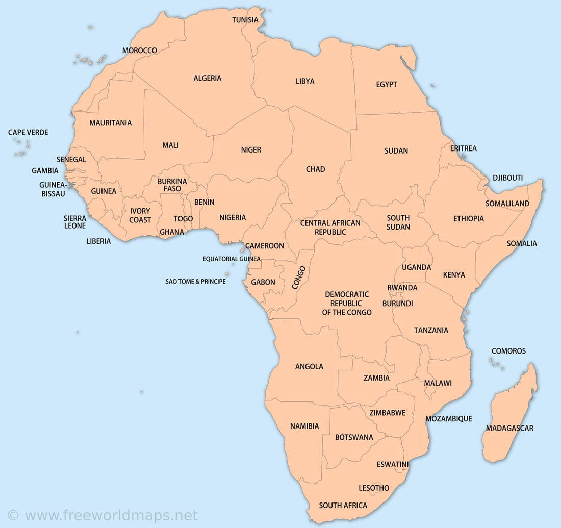
Africa spans nearly as far west to east as it does north to south. The Sahara - the world's largest hot desert - covers Africa's northern third, while tot he south lies bands of grassland, tropical rainforest, and more desert. The East African Rift system marks where shifting tectonic plates are splitting off the continent's edge. Africa has a wealth of cultures, speaking some 1,600 languages - more than on any other continent. Though the continent is mostly rural, Africans increasingly migrate to booming cities like Lagos, Cairo, and Johannesburg. Despite rich natural resources - from oil and coal to gemstones and precious metals - and partly as a result of them, many countries in Africa have endured colonization, corruption, and disease.
|
|
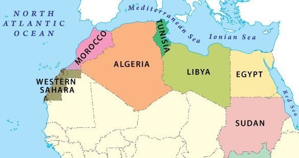
Northern Africa
Algiers, Algeria
|
Cairo, Egypt
|
Tripoli, Libya
|
Rabat, Morocco
|
Tunis, Tunisia
|
Laayoune, Western Sahara
|
|
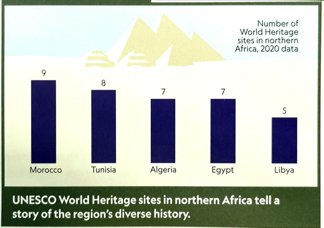
This region, which is made up of five counties, stretches from the Atlantic Ocean in the west to the Red Sea in the east. To the north the region is bounded by the Mediterranean Sea, while to the south lies the vast dry expanse of the Sahara. The world's longest river - the Nile - winds northward through Egypt, but most of the region is arid - meaning there is too little moisture to support trees or extensive vegetation. Most of the region's population lives in coastal areas or in the fertile valley of the Nile River. In recent years, the region has experienced widespread instability as a result of tensions between conservative Islamic groups and more liberal groups seeking modernization and democratic rule.
|
GEO WHIZ
|
|
The Basics
Largest Country: Algeria (919,595 sq mi)
Smallest Country: Tunisia (63,170 sq mi) Most Populous Country: Egypt (99,413,000) Least Populous Country: Libya (6,755,000) Predominant Languages: Arabic, French, indigenous languages Predominant Religions: Islam, indigenous beliefs Highest GDP per capita: Algeria $15,200 Lowest GDP capital: Morocco $8,600 Highest Life Expectancy: Algeria, Libya, Morocco (77 years) Lowest Life Expectancy: Egypt (73 years) |
Western Africa
Porto-Novo, Benin
|
Ouagadougou, Burkina Faso
|
Praia, Cabo Verde
|
Abidjan, Côte d’Ivoire (Ivory Coast)
|
Banjul, Gambia
|
Accra, Ghana
|
Conakry, Guinea
|
Bissau, Guinea Bissau
|
Monrovia, Liberia
|
Bamako, Mali
|
Nouakchott, Mauritania
|
Niamey, Niger
|
Abuja, Nigeria
|
Dakar, Senegal
|
Freetown, Sierra Leone
|
Lome, Togo
|
|
Stretching from Cabo Verde in the west, Mauritania in the northwest, and the barren Sahara int he north, to Nigeria in the southeast, 16 countries make up western Africa. Three countries - Burkina Fasco, Mali, and Niger - are landlocked, meaning they have no direct access to ocean trade. The remaining 13 have coastlines along the Atlantic Ocean or the Gulf of Guinea. Early kingdoms thrived in Mali, Ghana, and Benin, but European colonization disrupted traditional societies and economies, and left a legacy of political turmoil. Today, the countries are independent, but widespread use of French and English reflects the region's colonial past. Reliance on agriculture and falling global oil prices have left the region with a struggling economy.
|
GEO WHIZ
|
|
The Basics
Largest Country: Niger (489,191 sq miles)
Smallest Country: Cabo Verde (1,557 sq miles) Most Populous Country: Nigeria (203,453,000) Least Populous Country: Cabo Verde (568,000) Predominant Languages: French, English, Portuguese, Arabic, Spanish, indigenous languages Predominant Religions: Islam, Christianity, indigenous beliefs Highest GDP per capita: Cabo Verde ($6,900) Lowest GDP capital: Liberia ($1,400) Highest Life Expectancy: Cabo Verde (72 years) Lowest Life Expectancy: Guinea-Biseau (51 years) |
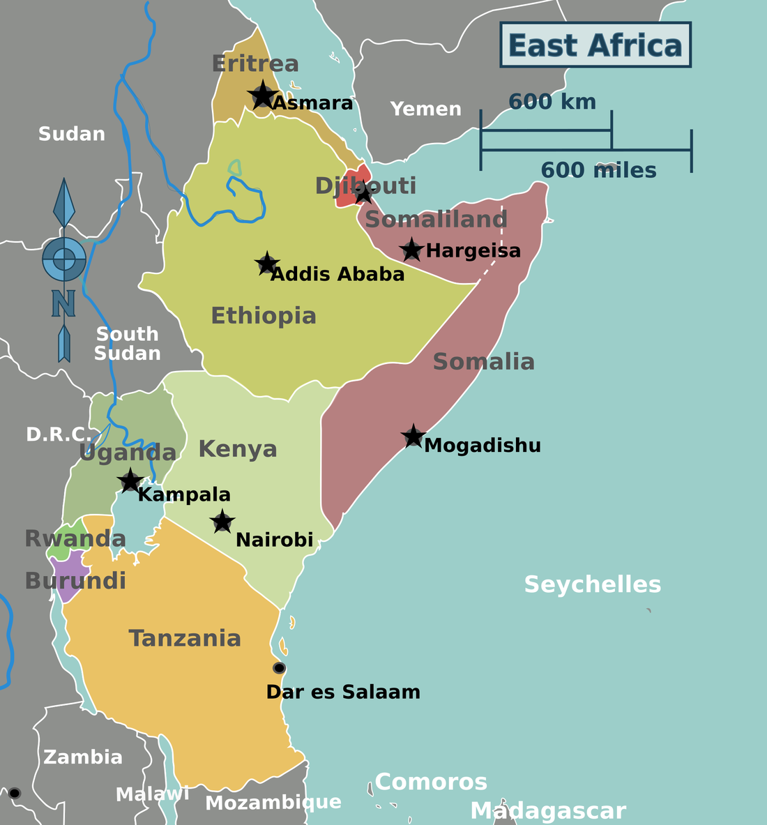
Eastern Africa
Gitega, Burundi
|
Djibouti, Djibouti
|
Asmara, Eritrea
|
Addis Ababa, Ethiopia
|
Nairobi, Kenya
|
Kigali, Rwanda
|
Mogadishu, Somalia
|

Dodoma, Tanzania
|
Kampala, Uganda
|
|
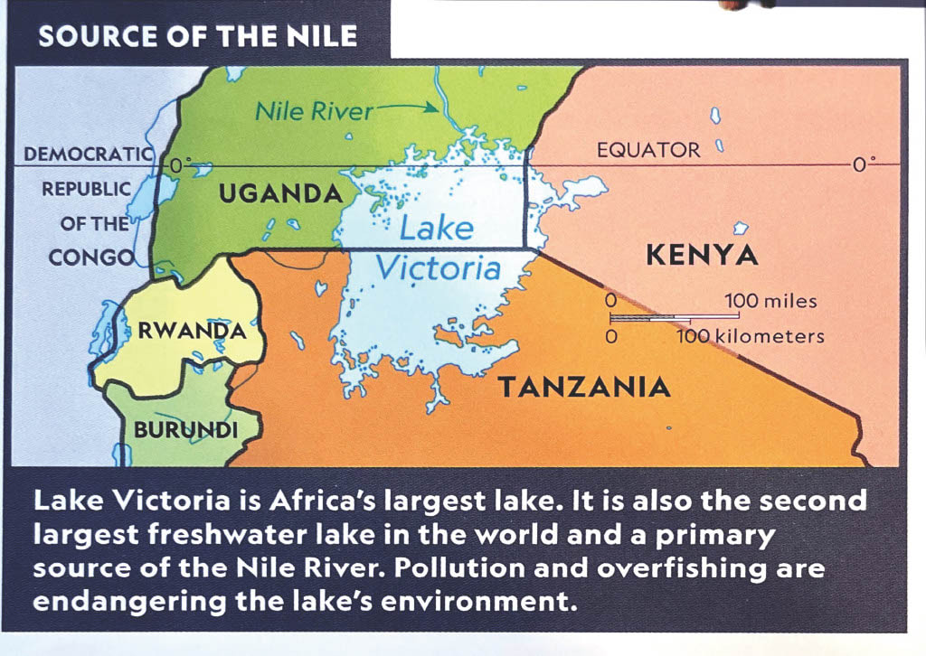
Eastern Africa's southern countries attract tourists to see big game - lions, elephants, giraffes, cape buffalo, zebras, wildebeests - that live on tropical grassland called savannas. Some also come to the region to climb its towering volcanic mountains, such as Kilimanjaro and Mount Kenya. Along the western border lies Africa's Great Lakes, a part of the Rift Valley where tectonic forces are gradually separating eastern Africa from the rest of the continent. Religious and ethnic conflicts have plagued the region's northern countries for many years, leading to the political separation of Eritrea from Ethiopia. Civil unrest combined with drought has led to widespread famine, especially in Somalia.
|
GEO WHIZ
|
|
The Basics
Largest Country: Tanzania (365,754 sq miles)
Smallest Country: Djibouti (8,958 sq miles) Most Populous Country: Ethiopia (108,386,000) Least Populous Country: Djibouti (884,000) Predominant Languages: French, English, Arabic, Kiswahili, indigenous languages Predominant Religions: Islam, Christianity, indigenous beliefs Highest GDP per capita: Djibouti, Kenya ($3,500) Lowest GDP capital: Somalia Highest Life Expectancy: Djibouti (63 years) Lowest Life Expectancy: Somalia (52 years) |
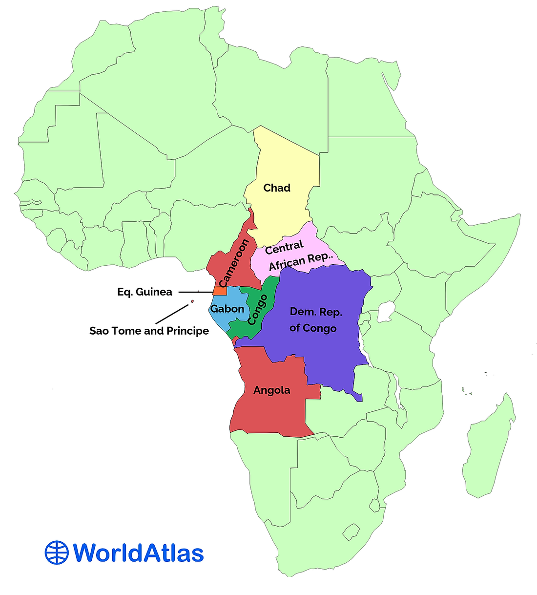
Central Africa
Yaoundé, Cameroon
|
Bangui, Central African Republic
|
N’Djamena, Chad
|
Brazzaville, Congo
|
Kinshasa, Democratic Republic of the Congo
|
Malabo, Equatorial Guinea
|
Libreville, Gabon
|
São Tomé, Sao Tome and Principe
|
Juba, South Sudan
|
Khartoum, Sudan
|
|
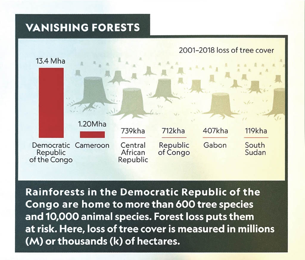
The Congo, a major commercial waterway of central Africa, flows through rainforests being cut for timber and palm oil plantations. This places a large area of Earth's biodiversity at risk. To the north, Lake Chad, a large, but shallow lake, fluctuates greatly in size due to high rates of evaporation, unreliable rainfall, and overuse by the 20 million people who live near its shores. Diamonds, copper, and chromium are mined in the Democratic Republic of the Congo (DRC) and the Central African Republic. Coffee is growing in the eastern highlands of the region, and livestock and cotton contribute to the economy of Chad. Religious and ethnic conflicts led to the separation of South Sudan from Sudan in 2011. Ongoing civil unrest and drought have led to widespread famine in South Sudan.
|
GEO WHIZ
|
|
The Basics
Largest Country: Democratic Republic of the Congo (905,354 sq miles)
Smallest Country: Sao Tome and Principe (362 sq miles) Most Populous Country: Democratic Republic of the Congo (85,281,000) Least Populous Country: Sao Tome and Principe (204,000) Predominant Languages: French, English, Arabic, Portuguese, indigenous languages Predominant Religions: Islam, Christianity, indigenous beliefs Highest GDP per capita: Equatorial Guinea ($36,000) Lowest GDP capital: Central African Republic ($700) Highest Life Expectancy: Sao Tome & Principe (65 years) Lowest Life Expectancy: Chad (51 years) |
Southern Africa
Luanda, Angola
|
Gaborone, Botswana
|
Moroni, Comoros
|
Mbabane, Eswatini (Swaziland)
|
Maseru, Lesotho
|
Antananarivo, Madagascar
|
Lilongwe, Malawi
|

Port Louis, Maritius
|
Maputo, Mozambique
|
Windhoek, Namibia
|
Victoria, Seychelles
|
Pretoria, South Africa
|
Lusaka, Zambia
|
Harare, Zimbabwe
|
|
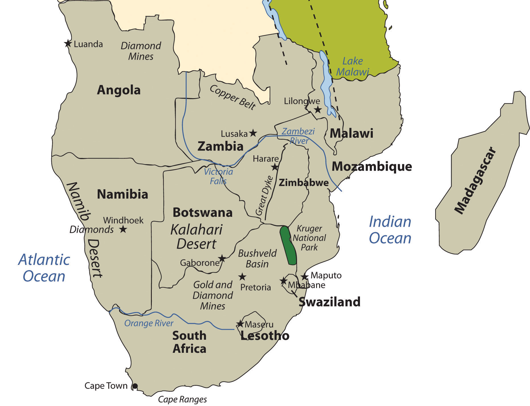
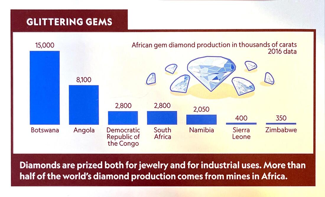
Ringed by uplands, the region's central basin hold the seasonally lush Okavango Delta and scorching Kalahari Desert. The mighty Zambezi thunders over Victoria Falls on its way to the Indian Ocean, where Madagascar is home to plants and animals found nowhere else in the world. Bantu and San are among the indigenous people who saw their hold on the land give way to Portuguese, Dutch, and British traders and colonists. The region offers a range of mineral resources and a variety of climates and soils that in some places yield bumper crops of grains, grapes, and citrus. Rich deposits of coal, diamonds, and gold have helped make South Africa the continent's economic powerhouse.
|
|
|
The Basics
Largest Country: Angola (481,353 sq miles)
Smallest Country: Seychelles (176 sq miles) Most Populous Country: South Africa (55,380,000) Least Populous Country: Seychelles (95,000) Predominant Languages: French, English, Arabic, Portuguese, indigenous languages Predominant Religions: Islam, Christianity, indigenous beliefs Highest GDP per capita: Seychelles ($28,900) Lowest GDP per capita: Malawi ($1,200) Highest Life Expectancy: Mauritius (76 years) Lowest Life Expectancy: Eswatini (52 years) |
GEO WHIZ
|
